


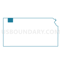
Atwood City Precinct 2, Rawlins County, Kansas
About
Outline

Summary
| Unique Area Identifier | 586349 |
| Name | Atwood City Precinct 2 |
| County | Rawlins County |
| State | Kansas |
| Area (square miles) | 0.37 |
| Land Area (square miles) | 0.37 |
| Water Area (square miles) | 0.00 |
| % of Land Area | 100.00 |
| % of Water Area | 0.00 |
| Latitude of the Internal Point | 39.80255510 |
| Longtitude of the Internal Point | -101.04112710 |
Maps

Graphs
Select a template below for downloading or customizing gragh for Atwood City Precinct 2, Rawlins County, Kansas


Neighbors
Neighoring Voting District (by Name) Neighboring Voting District on the Map
- Atwood City Precinct 1 East, Rawlins County, KS
- Atwood City Precinct 1 West, Rawlins County, KS
- Atwood Township Voting District, Rawlins County, KS